While much of the world’s attention is on Pakistan and the death of Osama bin Laden, my prayers and concern have faced a different direction: Paducah, Kentucky; Cairo, Illinois; and the lower Ohio River Valley.
Last night another 1.8 inches of rain fell at my house, south of Indianapolis, which will drain into the White River, then to the Wabash, and eventually into the Ohio. The last thing the Ohio River basin needs is more rain.

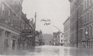
I grew up on the Ohio River, in Maysville, Kentucky. The water of that river still flows in my veins today. In that little town, the 1937 flood was the stuff of legend. At the time I grew up, a lot of people were still living who recalled and lived through the record flood of January 1937. My parents’ house was about 300 yards from where a floodwall stands today. As Mom and Dad were renovating the house, they discovered the water line from that flood halfway up the walls of the second story.
It’s hard to believe that a worse flood could come along, but it has. At Cairo, Illinois, near the confluence of the Ohio and Mississippi Rivers, the Ohio crested at 59.5 feet in 1937. The Ohio River reached 61.7 feet on the gauge at Cairo before the U.S. Army Corps of Engineers was able to breach the Bird’s Point levee, operating the Bird’s Point-New Madrid floodway and lowering the river levels at Cairo.

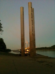
At Vevay, Indiana, along the banks of the Ohio, three towers stand that mark the water level of the 1937 flood. The flood of 2011, although downstream from Vevay, is topping those levels by 2-3 feet.
This is the “project flood” that the Mississippi River and Tributaries Project was developed to protect against. Had the Corps of Engineers not put the Bird’s Point-New Madrid floodway into operation, the Ohio River would have continued to rise, increasing pressure on the levees at Cairo and possibly causing a breach that could wipe out that town, leaving its 2,800 residents homeless.
The operation of the floodway has its own consequences, however. Breaching the Bird’s Point levee started the process of flooding over 130,000 acres of farm land in Mississippi County, Missouri. The intentional flooding will leave behind a layer of silt that will remain for a generation, damaging the land with a loss of topsoil and depositing pollutants that have accumulated in the silt and clay from the river water.
Just as the wind blows where it will, water flows where it will. Our efforts to control the flow of water, even in the interest of public safety and continued navigation, lead to difficult decisions. The water has to go somewhere, and it will change lives wherever it goes.
So prayers are offered for those along the lower Ohio River valley who watched anxiously to see what the river would do. Prayers are offered for those in Missouri whose lives and livelihoods have been profoundly affected. Prayers are offered for the leaders in the Corps of Engineers as they continue watching the “project flood” and the pressure it puts on the system as it moves down the Mississippi River basin.
As the nation looks at Pakistan, Old Man River keeps rolling through the heart of the country in his bloated state, impacting people and homes along the way.

Dean, my prayers are also with the people who are being affected by this historic flood.
Growing up as a river rat in farthest northern Kentucky, it seemed like life centered around the river. Sometimes my dad could not complete his mail route over a dirt road that periodically flooded. Stories of the 1937 flood were told again and again, as well as stories of the year the river froze and you could take a horse and wagon across (maybe the second decade of the last century?). It almost did this again in 1978, when we were back living near the place I grew up. We boated on the river, took rides on paddlewheelers, skipped rocks, took the ferry to Indiana or Ohio (no bridges then). The I-275 bridge from Indiana to Kentucky is named for my grandfather, who like most of the family up to and including my mother were born within a very few miles of the Ohio. It was a constant presence in our lives.
But always, we feared the floods. I read about this current one, and mourn in advance for the destruction in lives it will cause. Rivers, and especially those we have tried to tame, are the ever-present reminder that we can live in the boundaries of nature, but never control it. I’ve filled sandbags, dug out mud from basements, wondered at watermarks high on the walls of buildings. And years later, we face the same peril. It is a wonder and a sorrow.
Great article and oh so true. Thoughts from Susan bring back many memories. The river was always the focal point of activities. People up north here just don’t get it when I talk of the ’37 flood. The stories my dad told of standing on the roof of his house and of my mother in Illinois whose family was evacuated in a row boat tell of a time before media overload.
My husband teases me that the first time I took him “home” I kept telling him we had to see “the river”. After many trips south, I think he now gets it.
With flood walls our town was protected; but, so many in the county lost so much. The “wonder and sorrow” comment from above says it all.